Tuesday, June 9, 2009

South Bangka Regency

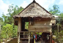
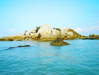
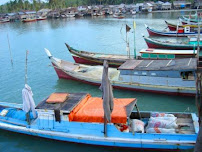
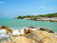
South Bangka Regency is located in the Bangka island and is one of the regencies in Bangka province, with the total area of appoximately 3,607,09 kilometres or 360.708 hectares. It is divided into 5 districts and 45 and 3 sub districts. Geographically, it is adjacent to central Bangka regency in the north, Gaspar straits in the east, Java sea and Bangka straits in the south and Bangka straits in the west. In the south part of Bangka island, it has a long island and several small islands. It consists of 27 named small island and 4 unnamed small islands. Lepar and Pongok islands can be bumper islands to develop and maximize the small islands surounding having their beach tourism potential.There are several characteristic islands that can be developed as fishing tourism such as Punai, Celangan islands and other areas surounding small areas since they have huge deposit of fish. Beside beach and maritime tourism, it has other potential tourism objects as well that can be developed. They are water tourism with its Nyelanding hot water bathing place, agro tourism with its pepper and orange plantation, and historical tourism with its Toboali and Penutuk fortresses.South Bangka regency has also potetial in the agriculture sector such as vegetables, fruit and crops. The crops include rice, corns, sweet potatoes, and beans.This regency has also huge potential in the fishery since this regency has 283,4 kilometres long beach with the total of sea is 10.640 square kilometres. For its potential of fish production can exceed until 64.000 tons per year while land potential to be developed is approximately 16.500 hectares. In the mining sector, granite, sand, kaolin, and tin can be found easily in almost all districts in South Bangka Regency.This regency has a chance to develop industrial sector, supported with government regulation that puts its Sadai area as an Industrial zone. With its strategic location, Sadai industrial zone is expected to be a industrial distribution network in Bangka belitung island province especially and generally for international network. Sadai industrial zone has approximately 500 hectares spreading from Tukak port to Sadai port. It is also eased since Sadai belongs to international ship channel.


Sunday, November 25, 2007

Bangka, My Home Town

island, Indonesia also spelled Banka or Banca, Indonesian Pulau Bangka

Bangka island, Bangka-Belitung propinsi (province), Indonesia. The island is situated off the eastern coast of Sumatra across the Bangka Strait, which is only 9 miles (14 km) wide at its narrowest point. On the east, Gaspar Strait separates Bangka from Belitung island. The soil is somewhat dry and stony but is largely covered with tropical vegetation. The virgin forest has almost disappeared because of mining and agricultural operations. Coastal areas contain few anchorages and are generally swampy, but the interior is hilly, with elevations up to 2,300 feet (700 metres). A number of the island’s rivers are tidal in their lower courses and are navigable for nearly 20 miles (32 km) inland. Bangka’s climate is hot and wet, with an average annual rainfall of approximately 120 inches (3,000 mm).

Bangka, which resembles the Malay Peninsula geologically, is composed of granite and slate that is frequently covered with sandstone, laterite, and alluvium. Granite outcrops form short, irregular hill chains. Bangka is one of the world’s chief tin-producing centres. The ore is found in many riverine alluvial deposits and in the alluvial strata on the slopes of small granitic hills; labourers of Chinese descent (Hakka) work in the mines under government contract and supervision. There are also deposits of lead, copper, tungsten, gold, iron, and manganese.

The inhabitants of the island of Bangka are predominantly immigrant Muslim Malay peoples. There are also aboriginal inhabitants consisting of a few hill tribes, probably of mixed Malay origin, who live by hunting, fishing, and collecting forest products. Rice, pepper, gambier (the source of an astringent), coffee, and coconut palms are cultivated on the island. There is an airport in the chief town and provincial capital, Pangkalpinang (situated on the eastern coast), and another is located in the chief port, Muntok (in the northeast).

The sultan of Palembang, in Sumatra, ceded Bangka to the British in 1812, but in 1814 the British exchanged the island with the Dutch for Cochin in India. Japan occupied Bangka in 1942–45; it was reoccupied by the Dutch in March 1946, and it became part of the inde Republic of Indonesia in 1949. In 2000 Bangka, Belitung, and other nearby islands were split from the province of Sumatra Selatan to form the separate Bangka-Belitung province. Area Bangka island, 4,375 square miles (11,330 square km); province, 6,244 square miles (16,171 square km). Pop. (2002) province, 900,197.


Design by Free blogger template